


With peak winds of 185 mph, Hurricane Dorian became the strongest storm on record to strike the Bahamas Sunday and among the top few most intense ever observed in the Atlantic Ocean. The Category 5 storm next threatens to bring hurricane force winds, coastal flooding and heavy rain to the east coast of Florida and Southeast U.S.
Dorian’s winds had only eased modestly, down to 180 mph at 11 p.m. Sunday, still generating “catastrophic conditions” in the northern Bahamas. The National Hurricane Center stated the storm made landfall on Grand Bahama Island at 11 p.m. after slamming into Great Abaco earlier in the day.
“Dorian remains an incredibly powerful hurricane,” the Hurricane Center wrote.
As the storm closes in on Florida’s east coast, the National Hurricane Center has posted hurricane and storm surge warnings for some areas. The storm surge is the storm-driven rise in water above normally dry land at the coast:
- The hurricane warning stretches from Jupiter Inlet (just north of West Palm Beach) to the Volusia/Brevard county line (just north of Titusville).
- The storm surge warning spans from near West Palm Beach to Titusville. In some areas the surge could reach 4 to 7 feet, the Hurricane Center projects.
These warnings are focused on the period from Monday night through early Wednesday. Tropical storm-force winds could begin in south Florida as soon as Monday afternoon and continue into Tuesday and Wednesday, perhaps reaching hurricane-force Tuesday depending how close to the coast Dorian tracks.
In addition to the wind and surge, about to three to six inches of rain is projected along Florida’s east coast.

Although the center of Dorian, containing its extreme Category 5 winds, may remain offshore Florida, its forecast track is so close to the coast that it necessitated warnings. “A small deviation to the left of the track could bring the intense core of the hurricane its dangerous winds closer to or onto the Florida coast,” the Hurricane Center wrote.

Beyond Florida, Dorian will take aim at coastal Georgia and the Carolinas Wednesday through Friday. “There is an increasing likelihood of strong winds and dangerous storm surge along the coasts of Georgia, South Carolina, North Carolina later this week,” the Hurricane Center wrote. “Residents in these areas should continue to monitor the progress of Dorian and listen to advice given by local emergency officials.”
Effects on the Bahamas
While Florida and areas farther north await effects from the monster storm, a “catastrophic” scenario is unfolding in the northwestern Bahamas, where the storm’s eyewall, the ring of destructive winds around the center, struck Sunday. On Great Abaco, which suffered a direct hit, the Hurricane Center warned of a “life-threatening situation” into Sunday evening.
[‘Pray for us’: Dorian snapping trees, tearing off roofs in the Bahamas]
 Bill Karins
✔@BillKarins
Watch #MarshHarbour go through the eye of #Dorian. Took 3 hours from western eyewall exit to now entering Southeast eyewall. #Bahamas

On Sunday night, as the storm’s eyewall rammed into Grand Bahama Island, the storm was predicted to unleash wind gusts over 200 mph, along with storm surge flooding of 18 to 23 feet above normal tide levels. “These hazards will cause extreme destruction in the affected areas and will continue for several hours,” the Hurricane Center stated.
 NWS Eastern Region
✔@NWSEastern
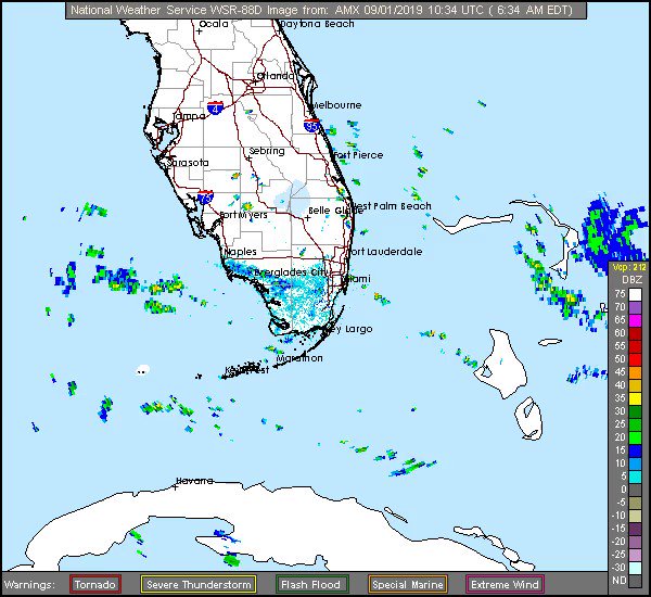
The eye of Hurricane Dorian is slowly approaching the eastern end of Grand Bahama Island Sunday evening as viewed from the Miami, Florida radar.
The storm’s core of devastating wind and torrential rain, totaling up to 30 inches, may sit for at least 24 hours over the northern Bahamas as steering currents in the atmosphere collapse, causing Dorian to meander slowly, if not stall outright, for a time.
In short, this is a storm that, depending on its exact track over the northern Bahamas, particularly Grand Bahama and the Abaco Islands, could reshape these locations for decades.
Across Florida’s east coast, residents continue preparing for any impact from Hurricane Dorian, even as the threat of a direct hit seems to have dissipated.
As of 11 p.m., the storm was 55 miles east of Freeport on Grand Bahama Island and was crawling west at 5 mph. The storm’s peak winds were 180 mph, and Dorian has maintained Category 4 and now Category 5 intensity for an unusually long period.
Storms this powerful typically tend to undergo cycles that weaken their high-end winds for a time, but Dorian has somehow avoided this dynamic.
As Hurricane Dorian heads toward Florida this Labor Day weekend, here are some tips to be prepare for the storm if you are potentially in its path.
The threat to Florida and the Southeast
After models run early Saturday shifted the storm track offshore Florida, some that were run late Saturday into Sunday shifted it back closer to the Florida coast.
Dorian has grown larger in size, which may have implications for the Florida forecast. Hurricane-force winds now extend outward up to 45 miles from the center and tropical-storm-force winds extend outward up to 140 miles (220 km). The latest forecast from the Hurricane Center calls for Dorian to remain a Category 5 storm until Monday night before slowly weakening, but remaining a formidable hurricane, as it moves close to Florida and northward to the Carolinas.
Because the storm is predicted to be a slow mover, effects from wind, rain and storm surge could be prolonged, lingering through the middle of next week on Florida’s east coast.
[Incredible views of Category 5 Hurricane Dorian near peak intensity]
Irrespective of the storm’s ultimate course near Florida’s east coast to the North Carolina Outer Banks — or even inland — significant coastal flooding is likely because of the force of Dorian’s winds and astronomically high or king tides.
The risk of a direct strike on Florida is less than it was a few days ago but has not been eliminated. Much depends on the strength of the high-pressure area that has been pushing Dorian west toward the northern Bahamas and Florida. The high acts as a blocking mechanism to prevent the storm from turning north out to sea, at least until the high diminishes in strength.
 Garrett Black@GBlack22wx

Most models show steering currents collapsing as Dorian nears Florida because of a weakening of the high, before it gets scooped up by a dip in the jet stream approaching the East Coast and starts turning north.
“The timing of the northwest or north turn is very critical in determining how close Dorian will get to the Florida peninsula on Tuesday and Wednesday,” the Hurricane Center wrote.
Some models don’t turn the storm soon enough, continuing to track the storm close enough for damaging impacts in parts of the state. One trend in the models overnight on Saturday and Sunday afternoon has been to show a slightly stronger high that brings the center of Dorian farther west, closer to the Florida coast and the Southeast coast, before making the northward turn.

Group of simulations from American (blue) and European (red) computer models from Sunday afternoon for Tropical Storm Dorian. Each color strand represents a different model simulation with slightly altered input data. Note that the strands are clustered together where the forecast track is most confident but diverge where the course of the storm is less certain. The bold red line is the average of all of the European model simulations, while the bold blue one is the average of all the American model simulations. (StormVistaWxModels.com)
In a statement, the National Weather Service forecast office in Melbourne, Florida, said “The situation has become more serious, especially for the east central Florida coastal counties,” based on recent forecast guidance.

The latest storm surge forecast for Florida shows that if the peak surge occurs at the time of high tide, the area from the Volusia and Brevard County Line to Jupiter Inlet could see 4 to 7 feet of water above ground, while the region from Deerfield Beach to Jupiter Inlet experiences 2 to 4 feet.
Farther north into coastal Georgia and the Carolinas, the forecast is also a nail-biter. Just small differences in where the storm starts to turn north and, eventually, northeast and the shape of the turn will determine where and whether Dorian makes landfall.
Scenarios involving a direct hit, a graze and a near miss appear equally likely based on available forecasts. As the Hurricane Center writes: “Residents in these areas should continue to monitor the progress of Dorian.”
The shape of the coastline from northern Florida through the Carolinas means there is a risk of significant storm-surge flooding there even if the storm’s center remains just offshore.
However, unlike with notorious recent storms such as Matthew and Florence, it’s unlikely that the Carolinas will experience devastating rainfall amounts from Hurricane Dorian, as the storm will pick up forward speed on nearing the Carolinas.

The storm in historical context
Dorian is tied for the second-strongest storm (as judged by its maximum sustained winds) ever recorded in the Atlantic Ocean, behind Hurricane Allen of 1980, and, after striking the northern Bahamas, tied with the 1935 Labor Day Hurricane for the title of the strongest Atlantic hurricane at landfall.
[Hurricane Dorian has smashed all sorts of intensity records in the Atlantic Ocean]
Dorian is only the second Category 5 hurricane to make landfall in the Bahamas since 1983, according to Phil Klotzbach of Colorado State University. The only other is Hurricane Andrew in 1992. The international hurricane database goes back continuously only to 1983.
The storm’s peak sustained winds rank as the strongest so far north in the Atlantic Ocean east of Florida on record. Its pressure, which bottomed out at 910 millibars, is significantly lower than Hurricane Andrew’s when it made landfall in south Florida in 1992 (the lower the pressure, the stronger the storm).
 Dakota Smith@weatherdak
Four straight years.
Five category five hurricanes.
Five incredible eyes.
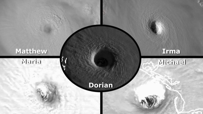
With Dorian attaining Category 5 strength, this is the first time since the start of the satellite era (in the 1960s) that Category 5 storms have developed in the tropical Atlantic in four straight years, according to Capital Weather Gang’s tropical weather expert Brian McNoldy.
tutti i video e le fotografie cliccando il link sotto riportato


